Anchal Bypass Road, Kollam: Location, Directions, Connectivity, Nearby Places
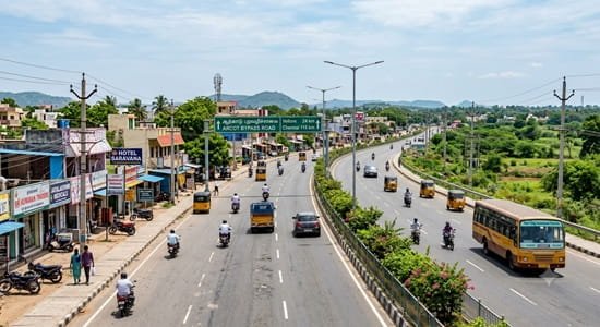
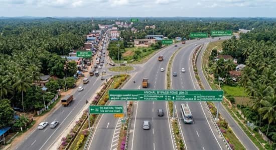
A journey through Anchal used to mean passing directly through the town’s busy commercial centre, even for motorists simply travelling between the Ayoor and Punalur sides. Anchal Bypass Road changed that movement pattern by creating an alternative around the central streets. The approximately 2-km corridor connects the Ayoor–Anchal approach at Kurishumukku with the Anchal–Punalur Road side, allowing through traffic to avoid some of Anchal’s busiest junctions. The bypass also serves developing residential areas around Padinjattinkara and Panayanchery, making it useful for local residents as well as regional travellers. Official Kollam district records document the Anchal Bypass project, while Kerala transport records confirm the bypass as part of local bus routes.
Quick Information About Anchal Bypass Road
| Particular | Details |
|---|---|
| Road Name | Anchal Bypass Road |
| Location | Anchal |
| District | Kollam |
| State | Kerala |
| PIN Code | 691306 |
| Approximate Length | About 2 km |
| Main Connections | Ayoor–Anchal Road and Anchal–Punalur Road |
| Nearby Areas | Kurishumukku, Padinjattinkara, Panayanchery, Anchal town |
| Nearby Towns | Ayoor and Punalur |
| Nearest Practical Railway Station | Punalur Railway Station |
| Major Railway Hub | Kollam Junction |
| Nearest Major Airport | Thiruvananthapuram International Airport |
| Transport Options | Buses, autos, taxis and private vehicles |
Where Is Anchal Bypass Road Located?
Anchal Bypass Road is located in Anchal in Kollam district, Kerala. Kerala Tourism places Anchal about 7.7 km from Ayoor and 12 km from Punalur, illustrating the town’s position between these two important regional centres.
The bypass runs around the developed town rather than forming part of a distant national highway. Its purpose is primarily to provide an alternative for vehicles that would otherwise travel through central Anchal.
Kurishumukku is an important reference point at the Ayoor-facing side. Padinjattinkara and Panayanchery are useful landmarks along the bypass corridor, while the other side connects with the road towards Punalur.
Because the road is comparatively short, using a specific junction or nearby establishment in navigation is usually more accurate than searching only for “Anchal Bypass.”
Directions to Anchal Bypass Road
From Ayoor
Travellers coming from Ayoor can follow the Ayoor–Anchal road towards Anchal. The bypass can be accessed around the Kurishumukku side before entering the busiest central portion of town.
This is a convenient approach for motorists arriving from the western side or from roads connected with Chadayamangalam and the wider MC Road corridor.
From Punalur
From Punalur, travel towards Anchal using the Anchal–Punalur road. The bypass connects with this approach before traffic needs to continue through central Anchal.
Punalur is roughly 12 km from Anchal according to Kerala Tourism.
From Central Anchal
People already inside Anchal town can access the bypass using local roads connecting the market and residential neighbourhoods with its junctions.
For a destination within the town itself, using the bypass may not always be necessary. Its biggest advantage is for traffic moving across Anchal rather than stopping in the centre.
Ayoor and Kottarakkara Connectivity
The Ayoor-facing end of the bypass gives travellers access towards Ayoor and, through the wider regional network, towards Chadayamangalam and Kottarakkara.
Kerala PWD records identify the Ayoor–Anchal–Punalur Road as a state-highway corridor maintained through its Anchal roads section.
This connection is particularly useful for motorists travelling between western Kollam district and the Punalur side because the bypass reduces the need to negotiate every central Anchal junction.
Connectivity Towards Punalur
Punalur is one of the most important nearby towns and an important gateway towards eastern Kollam.
From the Punalur-facing end of Anchal Bypass, travellers can continue towards Punalur and then connect with roads towards Thenmala and other eastern destinations.
The Kerala Infrastructure Investment Fund Board has also identified the Punalur–Anchal corridor as part of the wider Hill Highway network, highlighting the importance of this regional connection.
Connectivity Towards Kulathupuzha
Anchal also has road connectivity towards Kulathupuzha, providing access deeper into eastern Kollam district.
Kerala PWD’s road register identifies the Ayoor–Kulathupuzha Road among the state-highway roads handled by its Anchal section.
Travellers heading from the bypass towards Kulathupuzha should follow the appropriate local junction rather than continuing automatically towards Punalur.
Bus and Local Transport
Buses remain one of the main forms of public transport in Anchal. Services connect the town with Punalur, Ayoor and surrounding settlements.
Importantly, official Kerala transport records show routes that specifically use Anchal Bypass. A Kerala Gazette route listing, for example, identifies an Anchal private-bus-stand–Bharathipuram service passing through Anchal Bypass.
Kerala Motor Vehicles Department documents also record proposed services using Bypass Road and the Anchal private bus stand junction.
However, passengers should not assume every bus serving Anchal travels along the bypass. Some services continue through the central bus stand or other town roads.
Railway Connectivity
Anchal does not have its own railway station.
Punalur Railway Station is the nearest practical railhead for many travellers. Kerala Tourism places Punalur about 12 km from Anchal town.
For passengers requiring a larger railway hub with a wider selection of long-distance services, Kollam Junction is another important option.
The better station depends on the train being taken rather than distance alone. Travellers should first check which station their train serves and then arrange the road journey accordingly.
Airport Connectivity
Thiruvananthapuram International Airport is the nearest major airport commonly used from Anchal.
Airport-bound passengers can travel through the regional road network towards the Thiruvananthapuram side. Since the journey involves state highways and town roads rather than an uninterrupted expressway, actual travel time can vary.
Leaving additional time for traffic, weather and road conditions is advisable when catching a flight.
Nearby Areas Around Anchal Bypass
1. Kurishumukku
Kurishumukku is one of the main reference points for accessing the bypass from the Ayoor-facing side. It is useful for travellers approaching from Ayoor and adjoining western areas.
2. Padinjattinkara
Padinjattinkara is associated with the bypass corridor and its surrounding residential development.
3. Panayanchery
Panayanchery is another important locality beside the road. Recent reporting identifies the Padinjattinkara–Panayanchery section specifically as part of Anchal Bypass Road.
4. Anchal Town
Central Anchal remains the area’s main commercial centre. Markets, shops, banks, schools, healthcare facilities and bus services are concentrated here.
The bypass does not replace access to the town; it simply provides another route for vehicles that do not need to pass through its busiest streets.
5. Yeroor
Yeroor is another nearby locality accessible through connecting roads from Anchal. Travellers heading there should use the appropriate local route rather than remaining on the bypass for its full length.
Road Design and Driving Conditions
Anchal Bypass is an urban traffic-relief road rather than a national-highway expressway. Drivers therefore need to expect local junctions, pedestrians and vehicles entering from nearby properties.
Road safety deserves particular attention. Local reporting has highlighted crashes associated with speeding on the bypass, especially on relatively open sections.
Motorists should follow posted limits and reduce speed around junctions and residential stretches. Night driving also requires additional attention because animals have been reported crossing the bypass.
Frequently Asked Questions
Q1. Where is Anchal Bypass Road located?
A. Anchal Bypass Road is located in Anchal in Kollam district, Kerala. It provides an alternative route around the central part of Anchal and connects the Ayoor-facing and Punalur-facing approaches.
Q2. How long is Anchal Bypass Road?
A. The main Anchal Bypass corridor is approximately 2 km long. It is a relatively short town bypass designed primarily to divert through traffic away from central Anchal.
Q3. Which towns are connected through Anchal Bypass?
A. The bypass is particularly useful for traffic moving between the Ayoor side and Punalur side. The wider road network also provides connections towards Kottarakkara, Yeroor and Kulathupuzha.
Q4. Which railway station is nearest to Anchal Bypass?
A. Punalur Railway Station is the nearest practical railway station for many travellers. Kerala Tourism places Punalur approximately 12 km from Anchal.
Q5. Which areas are near Anchal Bypass Road?
A. Kurishumukku, Padinjattinkara, Panayanchery and central Anchal are among the main nearby areas. Punalur, Ayoor and Yeroor are also conveniently accessible through connecting roads.